Bryce Canyon National Park: Southwest Adventure 2016
In many ways, you could say that Bryce Canon National Park, is the sister park to Zion National park. More than anything, these two parks are tied together by geology. The rocks at the bottom of Bryce Canyon are from the same formation as the rocks at the top of Zion Canyon. This article details my brief experiences with photography in Bryce Canyon National Park.
Back in October of 2016, I went with my family on a week road trip through the American Southwest. This trip included stops at the Grand Canyon, the Durango and Silverton Narrow Gauge Railroad, Mesa Verde National Park, and Zion Nation park, among other places.
Even though this wasn’t a dedicated expedition purely for photography — not even for me — I couldn’t help but bring my cameras, and too much gear with it, to photograph this amazing places. Unfortunately, I didn’t have anywhere near enough time to fully explore, or become remotely familiar with these places. At the same time, having to think on your feet and work on the fly is something we always have to deal with.
As with the above linked articles, this “guide”, and I use that term loosely, is aimed at telling the story of my experience in Bryce Canyon National Park, and to provide some ideas on how to approach photographing it on a foreshortened timescale.
In terms of time constrains Bryce Canyon NP was second only to Mesa Verde in how little time I had to work. Part of that is that we were staying at the Zion Lodge in Zion NP, and drove over to Bryce as a day trip. However, unlike Mesa Verde, which is a mere 40 minute drive from Durango, Co., Bryce Canyon is close to a 2 hour drive from Zion NP.
The longer drive, a late start, and the desire to be back at the Zion Lodge in time for dinner — and before it started getting dark — curtailed just how much time we had to explore Bryce Canyon.
Due to our limited time in the park, we basically drove to the end of the one road in the park, to Rainbow Point, and started working back towards the visitor center stopping at each of the lookout points and pull offs.
Bryce Canyon Geography
Geologically and geographically Bryce Canyon and the rest of the Colorado Plateau system are quite interesting. I’m seriously thinking about writing a border article on the geography of the Colorado Plateau as its something that I found both quite fascinating when the overall structure finally dawned on me. Moreover, in some ways understanding the border geography of the Colorado Plateau, would have better prepared me for navigating and potential photographic opportunities that I missed.
Put simply, from the Grand Canyon north to roughly the middle of Utah, is a large area of geological uplift called the Colorado Plateau. Bryce Canyon, or rather the Paunsaugunt Plateau, tend to form the highest elevations in of the Colorado Plateau.
As an aside, much like I did in my Grand Canyon article, I’ll offer the same commentary/caution about elevation here too. Bryce Canyon, the rim at least, is near or exceeds 8000 feet in elevation, and by quite a bit in some respects. For example, Rainbow Pont is listed at 9115 feet. This is nearly as high as Silverton, Colorado, and more than 2000 feet higher than the South Rim of the Grand Canyon.
Because of the altitude, the same cautions for people use to much lower terrain apply. At 9000 feet, there is nearly 30% less available oxygen to breathe as compared to sea level. Generally this won’t pose any real problems for most people, at least when walking around on mostly flat and level terrain. However, when exerting yourself, having 30% less available oxygen can become more of a factor. What would take you 3 breaths worth of oxygen at sea level would take nearly 4 throughout most of Bryce Canyon.
With that out of the way, back to the geology.
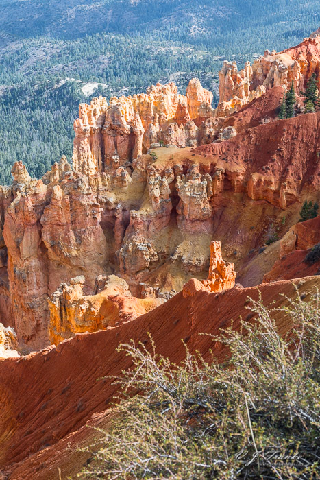
Bryce Canyon is part the larger Grand Staircase geography of the Colorado Plateau. Specifically it’s part of th top most “step” known as the Pink Cliffs. The Pink Cliffs get their name from the pink- and red-colored Clarion Formation limestones.
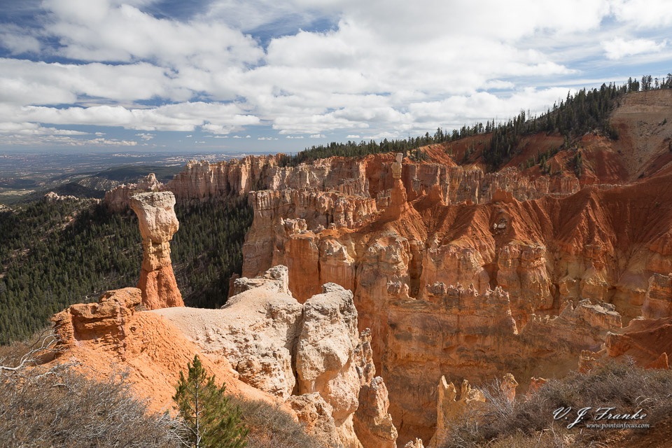
Like all limestones, the limestones that make up Bryce Canyon are relatively easily eroded. This process, especially in the relatively soft limestones of Bryce Canyon results in the production of two of the parks major geological attractions; arches[1] and hoodoos.
Arches, perhaps more technically called windows, are just what the name implies; a rock bridge that spans over an opening. In this article the by the National Park Service, they assert that by convention the hole in the arch must be at least 3 feet by 3 feet.
The other major geological structure that Bryce Canyon is known for are hoodoos. Hoodoos are free standing columns of rock. Frequently, hoodoos have larger capstones of somewhat harder rock that appear to be balanced on top of the finer pillar.
The widespread formations of arches and hoodoos in Bryce Canyon is not unsurprising, as hoodoos are one of the potential end stages for an arch. Water and snow erode the soft limestones that make up the Paunsaugunt Plateau from the edges in. While almost all rock appears generally hard to us, erosively, it’s not all created equal, and softer material erodes away first. Where harder rock layers are above softer ones, the softer material below can be eroded out from under the harder layer leaving a natural bridge, arch, or window.
As erosion continues to remove rock, eventually the arch spanning the gap will become insufficiently strong to support its own weight and collapse. If, when it collapses, it leaves a free standing pillar at one end, this pillar would be called a hoodoo. Of course, I say a hoodoo is one potential end to an arch, as it’s also possible that the pillar that would be the hoodoo is insufficiently strong and collapses or is knocked over in the collapse of the arch.
Interestingly, arches and hoodoos are not protected by the National Park Service, and in my opinion at least nor should they be. They are let to naturally erode over time instead of being shored up. Ultimately, this means that an arch or hoodoo that was standing on one visit may not be standing on a return visit.

In any event, the final interesting point I want to make about the geology of Bryce Canyon goes back to the Grand Staircase, the Colorado Plateau, and the relationship with Zion Canyon further down the staircase. One interesting aspect of Bryce and Zion National Parks, is that they are geologically related. The geology of Bryce Canyon, or at least the bottom most layers in the Dakota sandstone formation, can be traced directly as the highest layer exposed in Zion Canyon (at the top of Horse Ranch Mountain in the Kolob Canyons section of Zion National Park).
Bryce Canyon, and Bryce Canyon National Park
One thing to be aware of, and something I wasn’t at all aware of at the time, is that unlike say Zion Canyon National Park or The Grand Canyon National Park, Bryce Canyon does not make up the majority of Bryce Canyon national park. In fact, because of this, while I was at Bryce Canyon National Park, I completely missed seeing Bryce Canyon itself. While we drove up to Bryce Point, the parking lot was full, and it was stating to get late, and so we didn’t stop. At the time, this wasn’t really an issue, as our mistaken belief was that along the whole road out to Rainbow Point, we’d been seeing Bryce Canyon, not looking off the edge of the Pink Cliffs.
In retrospect, this error wasn’t even entirely clear to me until I started trying to figure out what to call the border area I was photographing (and honestly I’m still not entirely sure).
That’s not to say that there aren’t spectacular things to see along the road out to Rainbow point, but if your intent is to see Bryce Canyon itself you’ll want to make sure you actually turn off on the road to Inspiration Point and Bryce Point, or alternatively Sunset Point.
Of course, by missing Bryce Canyon proper, I also missed some of the most spectacular hoodoo and window/arch structures in the park without even realizing it. Honestly, now that I’m properly looking at maps and what not it makes a lot more sense as to why I found Bryce Canyon National Park to be somewhat underwhelming.

I would reiterate the point that this is ultimately the problem with trying to explore national parks, even relatively small ones, on a very tight time frame. There’s a whole lot you can miss, I missed the namesake canyon here, when you’re in a hurry. Learn from my mistake, take your time.
Top of the Canyon Versus Bottom of the Canyon
Throughout this series of articles, I’ve been talking about the kinds of geography of various canyons and how that poses challenges and opportunities for a photographer. One of the big points, or differences, I’ve been talking about are top of the canyon parks, and bottom of the canyon parks.
The Grand Canyon, Mesa Verde (though not technically a canyon), and Bryce Canyon are what I call top of the canyon situations. All of these parks are similar in that your primary access is to the top of the canyon or plateau. This in tern means that the images you make of the canyon will be a canyon as a hole in the ground.
On the other hand, Zion, Antelope Canyon, Monument Valley, and the Durango and Silverton railroad (most of it at least) are all what I would call bottom of the canyon situations. In these places you’re in the bottom of the valley or canyon looking up towards the rim. Images can still show a canyon, but it shows it as towering cliffs over your head as opposed to a hole in the ground.
Bottom of the canyon locations have some further advantages, as they tend to have interesting small scale things to shoot that aren’t usually available at top of the canyon locations. This includes things like rivers, streams, and pools of water; water seeps/weaps and waterfalls; and interesting rocks and structures in the rock walls.
Unless you’re hiking Bryce Canyon is going to be a top of canyon location. That said, Bryce Canyon proper, is much smaller than the Grand Canyon and as a result, must more approachable from a photographic standpoint. Or at least from the perspective of dealing with a massively grand landscape.
Of course, Bryce Canyon NP does have a number of trails that go down into Bryce, and other, canyons so you can snoop around at lower levels — though most of the trails through Bryce Canyon itself and the Amphitheater formation in it are considered by the Park Service to be strenuous hikes.
Some Broader Points on Photography in Bryce National Park
As I noted previously, I totally hosed not getting to Bryce Canyon proper, that said looking at Bryce Canon National Park as a whole, there’s a number of observations that can be made about the park as a whole.
Bryce Canon proper, and the Pink Cliffs lie on the east side of the of the Paunsaugunt Plateau. This will, of course, have a strong impact on lighting and sun angles. Afternoon photography will have the Pink Cliffs area of the park falling into shadow. Moreover, many of the overlooks and lookout points along the Rainbow Point road look towards the north east, and therefore away from the setting sun.
Morning light will likely be better, depending of course on the specific locations and times.
The axis of Bryce Canyon itself runs more east-west, with walls along the north, west, and south sides. Between the overlooks at Bryce Point on the southeast end, and Sunset Overlook along the northeast, there should be reasonable rim level opportunities, at least at sunrise, if not as well as sunset.
Though again, I would strongly suggest using software like The Photographers Ephemeris[2] to verify sun rise/set and emperies data for when you would be visiting Bryce Canyon National Park.
One exemption to all of this is the Mossy Cave Trail (again something I had no idea about), which is located outside of the main area of the park off Utah 12. Mossy Cave Trail is a 1.5 mile hike that climbs 300 feet up Water Canyon past a waterfall and to a mossy cave.
Pullouts Along the Rainbow Point Road
With the general points out of the way, at least as much as I can make general points, I’m going to dig into some more specific points about opportunities along the Rainbow Point road.
Generally speaking there are a lot of windy sections along this road. Moreover, in many places, especially towards the end by Rainbow Point, there are steep drop-offs near or immediately at the edge of the road on one or sometimes both sides. Caution is strongly advice, and this is not a road where you should be engaged in looking at the scenery instead of driving.
There are a number (by my count 10) pullouts for overlooks. Many of these are small parking lots, however, there are at least 2 (designated pullout on my table below) near Rainbow Point that are merely paved shoulders designed to accommodate 4-5 cars.

All of the pullouts and parking lots along this road are on the east side. This makes them a left tern across traffic for vehicles driving out to Rainbow Point, and a right turn for vehicles returning from Rainbow Point.
My advice, though it’s certainly not strictly necessary to do so, is to drive all the way to Rainbow Point first, then stop at each of the pullouts and parking lot, which will now be on the right, on the way back. The pullouts at mile 0.9, Black Birch Canyon (2.3), mile 2.5, and mile 4.9 on my table, are legally only accessible from the northbound (returning) lane as right turns in and out. All of the larger parking lots are accessible from either direction, though as I said, I found it was easier to stop with them on the right, instead of having to cross traffic.
The included map and distance table for the pullouts and parking lots that I’ve included with this post, starts from Rainbow Point at mile 0.
| Pullout | Miles From Rainbow Point |
|---|---|
| Rainbow Point | 0 |
| Pullout | 0.9 |
| Black Birch Canyon | 2.3 |
| Pullout | 2.5 |
| Ponderosa Canyon | 3.2 |
| Agua Canyon | 4.2 |
| Pullout | 4.9 |
| Natural Bridge | 5.6 |
| Farview Point | 7.4 |
| Swamp Canyon | 11.9 |
All of these overlooks offered pretty spectacular views of the the plateau below of the Pink Cliffs. Moreover many of them offered some interesting rock formations and hoodoos. That said, the natural bridge, at the aptly named Natural Bridge stop is definitely worth seeing.
As I said back in my introduction, I was operating under a number of time constrains when visiting Bryce Canyon NP, and as a result I was there and shooting during the middle of the day (almost everything I shot was shot between 11 AM and 2 PM). Obviously this is less than ideal in so far as lighting goes.
Dark Sky Capabilities
While I wasn’t there at night, I did take a moment to consult some light pollution maps. For the most part, Bryce Canyon NP should provide clear dark skies for astrophotography and night landscapes. Moreover, the relatively high altitude should help with the air being cooler, thinner, and more stable
However, there are a few towns near by and they are big enough and close enough to cause sodium light pollution in the sky. To the north of the park entrance is Bryce Canyon City, and to the east-northeast of Bryce Point is the town of Tropic.
Neither of these towns are big by any stretch of the imagination. That said, Tropic is nearly as big as Springdale, UT (outside of Zion, population ~550) and nearly the same distance from Bryce Canyon as Springdale is from the lodge in Zion. In the case of Springdale and Zion, I found that the town produced enough light pollution that there was a noticeable yellow sodium light glow in the sky in that direction.
Fortunately for Bryce Canyon NP, both Tropic and Bryce Canyon City are located to the north and east, and now the south which is where the best images of the Milky Way will be found. On the other hand, because most of the areas at Bryce Canyon are on the top of the plateau, not sheltered in the bottom of a canyon, the light blooms from these two towns could be much more impactful.
That said, based on light pollution surveys, the far end of the road to Rainbow Point should be very dark. Even looking south from Paria View overlook towards the south should net very good skies.
To the South of Bryce Canyon NP, the closest significant town is Kanab (pop 4500), which is 33 miles away, and partially shielded in a vally/canyon system. The only closer town to the southwest is Glendale (population ~400) at 22 miles away, and it’s also sheltered by geography.
Wrapping it Up
I’m going to wrap this up at this point. Of all the National Parks I visited on this trip, Bryce Canyon National Park is the one I have the least familiarity with, and all considered spent the least amount of time in. As such, I have a very hard time trying to come up with much specific advice. This is doubly compounded by my screwing up and not actually seeing Bryce Canyon itself.
Given my screw-up of not actually seeing Bryce Canyon itself, and the potential for great astrophotography and night landscapes, Bryce Canyon NP is definitely on my list of parks I’d like to revisit with a lot more time.
- I feel like I would be remiss to point out that there are a whole lot of terms that geologists and geographers use to describe rock formations that span some distance. Arches, bridges, windows, are all among the terms I’ve found. Most cases cite a paper in the Geological Society of America’s journal by Cleland published in 1910, which sets forth defilations for natural bridges and arches; more modern authors go on to take what I would best describe as “stabs” at defining windows, arches, and so forth based on various other conditions. An article in the USGS’s Geological Survey Bulletin 1393 makes some attempt to define arches as holes in the base of a structure and windows as holes higher up in a feature. Honestly, I’m really mentioning this because I generally find classifying things interesting. ↩︎
- The Photographers Ephemeris (TPE for short) is available for iOS and Android as a native application, as well as a web application that you can use on your PC or Mac. Personally, I find that the app version, at least the iOS app version, is vastly more capable than the web version and vastly prefer to use that as it makes much more information available including Milky Way positions and other interesting astronomical data. All versions can be found though photoephemeris.com. ↩︎
Comments
There are no comments on this article yet. Why don't you start the discussion?